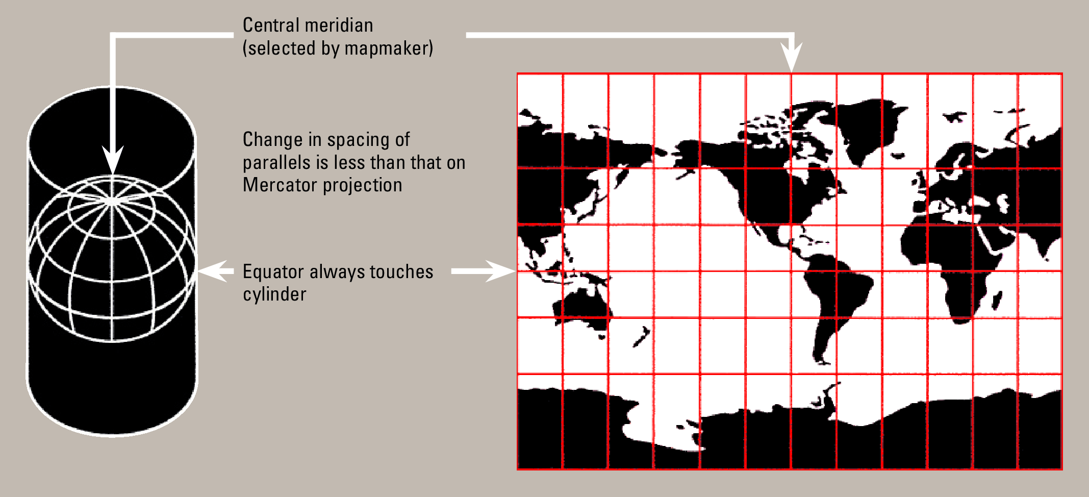
Data Projection#
The Earth is curved, but spatial data is often represented as flat maps. Converting from 3D to 2D causes stretching and inaccuracies in measurements like distance and area. Projections help transform data into flat maps while minimizing distortions.
CRS (Coordinate Reference System)#
A Coordinate Reference System (CRS) defines the location of spatial objects on the Earth’s surface.
There are two main types:
Geographic Coordinate Systems (GCS): Define locations using latitude and longitude on a spherical model of the Earth (e.g., WGS84).Projected Coordinate Systems (PCS): Flatten the curved surface into a 2D map using Cartesian coordinates (e.g., UTM).
Feature |
Geographic Coordinate System (GCS) |
Projected Coordinate System (PCS) |
|---|---|---|
Purpose |
Preserve shape over large areas |
Minimize distortions locally |
Measurement Units |
Degrees (Latitude/Longitude) |
Meters or feet |
Best for |
Global-scale mapping |
Local/regional mapping |
Common distortion |
Distance and area distortions |
Shape or scale distortions |
Spatial relationships like joins and overlays require matching coordinate systems. If datasets have different CRS, they must be reprojected, or else they will not align correctly, leading to incorrect analysis.
To manage projections and CRS, we use the geopandas package.
Working with CRS in GeoPandas#
from pathlib import Path
import geopandas as gp

# Define the input path
INPUT = Path.cwd().parents[0] / "00_data"
gdb_path = INPUT / "Biotopwerte_Dresden_2018.gdb"

# Load the data
input_data = gp.read_file(gdb_path, layer="Biotopwerte_Dresden_2018")
Checking the current CRS#
You can check the current coordinate system of the data using the crs attribute:
input_data.crs
<Projected CRS: EPSG:25833>
Name: ETRS89 / UTM zone 33N
Axis Info [cartesian]:
- E[east]: Easting (metre)
- N[north]: Northing (metre)
Area of Use:
- name: Europe between 12°E and 18°E: Austria; Croatia; Denmark - offshore and offshore; Germany - onshore and offshore; Italy - onshore and offshore; Norway including Svalbard - onshore and offshore.
- bounds: (12.0, 34.79, 18.01, 84.01)
Coordinate Operation:
- name: UTM zone 33N
- method: Transverse Mercator
Datum: European Terrestrial Reference System 1989 ensemble
- Ellipsoid: GRS 1980
- Prime Meridian: Greenwich
Key information:
Coordinate System: ETRS89/UTM Zone 33N (accurate for Central Europe)Coordinates: E and N represent Easting (X) and Northing (Y) in cartesian CRSUnits: Meters
EPSG Code
An EPSG code is a unique identifier for coordinate reference systems. You can search for EPSG codes for your region using EPSG.io from MapTiler.
Example: Geographic Coordinate System
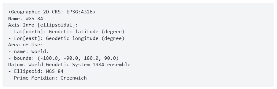
Fig. 11 Example of a Geographic Coordinate System#
In this example, the key information are:
Coordinate System: WGS 84, a global CRS, covers the entire EarthCoordinates: Latitude and Longitude, representing Northing and EastingUnit of Measurements: Degrees
A geographic CRS (such as WGS84) uses latitude and longitude in degrees. When using GCS for maps, the height (Z values) is typically ignored, resulting in a Geographic 2D CRS.
Assigning a CRS#
If the crs output is None, it means the dataset does not have a CRS assigned.
You can manually set the correct CRS (based on metadata) using the .set_crs() method:
data = input_data.set_crs("EPSG:25833")
Reprojecting the data#
To transform the data into a different coordinate system (reprojection), use the .to_crs() method.
There are two ways to specify the target CRS:
1. Using an EPSG code as a string
data_2 = input_data.to_crs("EPSG:3035")
data_2.crs
<Projected CRS: EPSG:3035>
Name: ETRS89-extended / LAEA Europe
Axis Info [cartesian]:
- Y[north]: Northing (metre)
- X[east]: Easting (metre)
Area of Use:
- name: Europe - European Union (EU) countries and candidates. Europe - onshore and offshore: Albania; Andorra; Austria; Belgium; Bosnia and Herzegovina; Bulgaria; Croatia; Cyprus; Czechia; Denmark; Estonia; Faroe Islands; Finland; France; Germany; Gibraltar; Greece; Hungary; Iceland; Ireland; Italy; Kosovo; Latvia; Liechtenstein; Lithuania; Luxembourg; Malta; Monaco; Montenegro; Netherlands; North Macedonia; Norway including Svalbard and Jan Mayen; Poland; Portugal including Madeira and Azores; Romania; San Marino; Serbia; Slovakia; Slovenia; Spain including Canary Islands; Sweden; Switzerland; Türkiye (Turkey); United Kingdom (UK) including Channel Islands and Isle of Man; Vatican City State.
- bounds: (-35.58, 24.6, 44.83, 84.73)
Coordinate Operation:
- name: Europe Equal Area 2001
- method: Lambert Azimuthal Equal Area
Datum: European Terrestrial Reference System 1989 ensemble
- Ellipsoid: GRS 1980
- Prime Meridian: Greenwich
2. Using an EPSG code as an integer
data_3 = input_data.to_crs(epsg=3035)
data_3.crs
<Projected CRS: EPSG:3035>
Name: ETRS89-extended / LAEA Europe
Axis Info [cartesian]:
- Y[north]: Northing (metre)
- X[east]: Easting (metre)
Area of Use:
- name: Europe - European Union (EU) countries and candidates. Europe - onshore and offshore: Albania; Andorra; Austria; Belgium; Bosnia and Herzegovina; Bulgaria; Croatia; Cyprus; Czechia; Denmark; Estonia; Faroe Islands; Finland; France; Germany; Gibraltar; Greece; Hungary; Iceland; Ireland; Italy; Kosovo; Latvia; Liechtenstein; Lithuania; Luxembourg; Malta; Monaco; Montenegro; Netherlands; North Macedonia; Norway including Svalbard and Jan Mayen; Poland; Portugal including Madeira and Azores; Romania; San Marino; Serbia; Slovakia; Slovenia; Spain including Canary Islands; Sweden; Switzerland; Türkiye (Turkey); United Kingdom (UK) including Channel Islands and Isle of Man; Vatican City State.
- bounds: (-35.58, 24.6, 44.83, 84.73)
Coordinate Operation:
- name: Europe Equal Area 2001
- method: Lambert Azimuthal Equal Area
Datum: European Terrestrial Reference System 1989 ensemble
- Ellipsoid: GRS 1980
- Prime Meridian: Greenwich
Matching another layer’s CRS
Sometimes you want one dataset to match another dataset’s CRS:
data_4 = data_3.to_crs(input_data.crs)
data_4.crs
<Projected CRS: EPSG:25833>
Name: ETRS89 / UTM zone 33N
Axis Info [cartesian]:
- E[east]: Easting (metre)
- N[north]: Northing (metre)
Area of Use:
- name: Europe between 12°E and 18°E: Austria; Croatia; Denmark - offshore and offshore; Germany - onshore and offshore; Italy - onshore and offshore; Norway including Svalbard - onshore and offshore.
- bounds: (12.0, 34.79, 18.01, 84.01)
Coordinate Operation:
- name: UTM zone 33N
- method: Transverse Mercator
Datum: European Terrestrial Reference System 1989 ensemble
- Ellipsoid: GRS 1980
- Prime Meridian: Greenwich
Now both layers are aligned and spatial operations (joins, overlays, measurements) can be performed correctly.